Near Valyermo, California, outside of Palmdale, the locals have placed signs where Pallet Creek Road crosses the San Andreas Fault. They picked a really nice spot too, as you have a sag area, fault scarp, and offset streams all easily visible from there. I recommend a visit!
I went for a ride on my motorcycle today. Just needed to just get out for a bit. Part of my journey took me through Idyllwild, via State 74 and 243. No photos of that section though, as I was too busy having fun on the motorcycle. The “slalom” section, as the locals seem to call it, on 74 heading up to Mountain Center is one of my favorites to ride. 243 was a lot better than on previous rides, owing to a lot less sand on the roadway and new paving from near Lake Fulmor down to Banning. Quite a bit of fun can be had up in the mountains on a motorcycle, even at 55 mph.
It had been a while since I’d gone out that way and needed to check on some things to see if they still remained. I was pleasantly surprised to find the US 60 sign still remaining on I-10 at the split in Beaumont. It is the last one as the rest have long since been replaced. When this one will is still a mystery but I doubt it will last much longer.
Signage at the 10 / 60 split with the US 60 shield partially visible behind the State 60 overlay.
Heading west on I-10, I followed a bit of old US 99 just west of Cherry Valley Blvd near Calimesa, where a section of Roberts Road (original US 99) will be realigned and eventually destroyed, lost to another residential development. Here, there is a beautiful section of 1925 concrete that is still relatively pristine. It was bypassed in 1937 by an new alignment, which is now mostly underneath I-10.
Looking easterly from the end of the paving near I-10. Future “Roberts Road” can be seen in the background on the right-hand side.
1925 date stamp. Happened to be right where I stopped the motorcycle for a photo.
My motorcycle and 99, complete with the 99 license plate.
It was a long ride but a lot of fun. A bit warm in my leathers at times, mostly when stopped at lights. I did find one thing that was a bit surprising in Menifee, after I stopped for fuel. While I commend their efforts, they have incorrectly marked a section of Antelope Road south of Newport Road as “Historic US 395”. It is even painted on the roadway like the US 66 shields in the Mojave Desert. US 395 did pass through here, but along the path of the freeway. The two-lane version of 395 followed the northbound lanes I-215 to about Garbani Rd and then the southbound lanes north of there.
In 1958, when the East Los Angeles Interchange started to be built, the routes that were planned to go through it were a little different that what is there today. I-10 was originally to be State 26 and I-5 was a part of US 99. US 101 remained the same. State 60 was to be State 26. The routing of the interstates through cities wasn’t quite settled yet and many of the roads were planned to be State or US routes.
After the signs were installed, some of them were temporarily overlaid until the Pomona Freeway connections were completed. A portion of the original route planned for that freeway, State 26, was visible. While some have speculated it was actually US 60 underneath there, reverting to State 60 after the 1964 route renumbering, these plans show otherwise. How far east the State Route 26 signage would have gone does remain unknown. It is likely it would have gone at least as far as the 57, if not all the way to the 71, as US 60 was effectively terminated at the present junction of I-10 and State 71 about 1960.
1958 plans for signage at the I-5/I-10/US 101/SR-60 Interchange (58-7vc41)1958 plans for signage at the I-5/I-10/US 101/SR-60 Interchange (58-7vc41)Plans in 1960 reflecting the shift to more Interstates routes (60-7vc5)Plans in 1960 reflecting the shift to more Interstates routes (60-7vc5
For additional photos and information about the interchange, head on over to the East Los Angeles Interchange page.
In June 2019, I sent a message to Caltrans requesting a change in the signage on I-805 northbound at El Cajon Blvd. The sign didn’t reflect the lane assignments and can be confusing to motorists not familiar with the interchange. In November, I got a response and they will not only change the sign but will move where it is placed. I thought that was pretty cool. Once again, it takes so little to make a positive change. I encourage others to do so as well.
My message:
CSR Ticket Number:
757911
Date Submitted:
2019-06-17 14:04:28
Date Completed:
2019-11-12 00:00:00
California County:
San Diego
State Highway Route:
805
Nearest Town or City:
San Diego
Nearest Cross Street:
El Cajon Blvd
Mode of Transportation:
Motorcycle
Direction of Travel:
Northbound
Date & Time Situation Noticed:
2019-06-17 12 noon – 1 pm
Type of Situation:
Signs – Missing, Broken, Blocked or Down
Description of Situation:
NB El Cajon Blvd exit sign is missing an EXIT ONLY tab and optional lane arrow. It can be confusing to motorists that don’t realize there are two possible lanes to use to exit at El Cajon Blvd when heading NB.
Geographic Location of Situation:
On NB I-805 approaching El Cajon Blvd
Caltrans response:
Message from Customer Service Liaison: Our Traffic Operations Engineer reviewed this issue and provided the following response. You can expect to see a project in the near future. Thank you for bringing this to our attention. Traffic Safety & Operations (South Region) is recommending the existing overhead panel be upgraded and re-positioned to centered above the two lanes of the exit ramp and also, additional sign be installed at the northbound I-805 exit ramp to El Cajon Boulevard per California Manual on Uniform Traffic Control Devices (CA MUTCD), 2014 Edition. We will initiate a Minor B project to upgrade the existing overhead panel and forward a request to Operations Support to install “RIGHT LANE MUST EXIT SIGN” and 8-inch solid white line approaching the exit ramp.
Road signs come in many different sizes, shapes, and colors. Each one carries a specific meaning to help guide you down the road in a safe manner. This installment will discuss each of the types of signs and what they mean. Road signs come in a variety of colors. Each color has a meaning, which can be quite important to know. The colors run from red, yellow, white, blue, green, brown, and orange.
Old stop sign along Topanga Canyon Blvd in Los Angeles, CA.
Red signs mean something is prohibited. Only a few signs use this color – stop signs and wrong-way signs are the most common of these. Stop signs are also the only one that is octagonal. The color red was not the first choice, however. Stop signs used to be yellow with black lettering. Color might depend on where you were. Eventually, stop signs became standardized with a red background and white lettering. Yield signs and some no parking signs also use this color scheme. While yield signs don’t prohibit movement, they are there to warn you of opposing or side traffic.
High wind advisory sign along State 41 in central California/
Yellow signs are advisory or warning. Things such as upcoming intersections, curves, and other roadway hazards are generally marked with yellow signs. Curves are a good example of this. The speed signs at curves are advising you of a safe speed for the curve. They aren’t a speed limit for the curve. It is a generally good idea to travel at the advised speed. Depending on many conditions, you may be able to go faster that the posted speed. With this in mind, I have found that 25 mph seems to be a breaking point for curves. Curves posted at 25 mph or higher can generally be driven faster. When they are posted lower than 25 mph, slowing down is highly advised. I’ve seen speeds as low as 5 mph posted on some roadways. I’ve also seen speeds as high as 60 mph. A curve with that high a speed is not a problem, but may be in an area with few curves and it is nice to know you don’t have to slow for it. Upcoming intersections are also posted with yellow signs. These signs tell you not that one is coming up but what type it is. Some signs are customized to show specific intersections, especially if it is a blind intersection in a curve.
Signage heading southbound toward Solemint Junction. Hwy 14 used to turn here to head east on Soledad Canyon Road from 1963-1972.
Black and white signs are regulatory signs, meaning they show some sort of rule that must be obeyed. Speed limit signs, for example, use this scheme. This is different than the curve advisory signs, which also show speed, as these signs show the maximum limit, not the advised limit. Parking signs are also generally in black and white as they limit or restrict parking in an area. Other signs in this category include bike lanes, passing, and other signs restricting either the movement or type of vehicle allowed in an area or lane.
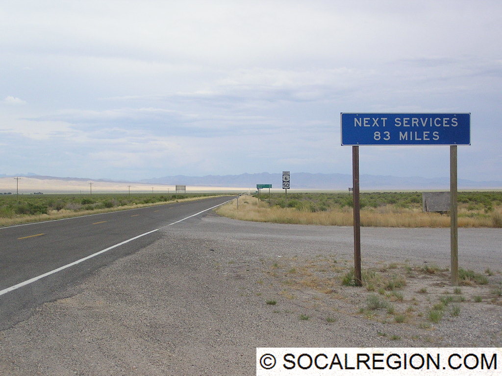
Next services sign in Utah, which are located in Hinckley.
Blue signs are very specific in use. They act as guides to hospitals, telephones, and where services can be obtained. Roadside services can include gas stations, food, and lodging. These signs can be quite helpful for roadway users that are unfamiliar with the area and are not sure what sort of services can be obtained at a particular exit. Use of these signs varies by state as well. Some states show specific businesses, where others are more general, e.g. “Gas, Food, Lodging – Next Exit”.
Signage at a roadway junction.
Green signs are also guide signs. These give directions, by use of an arrow, to locations such as cities and roadways. They also give mileage to locations along a route. On freeways they generally show distances to the next exit, where others show distance to the next three cities. They may also mark things such as bike routes, which are roadways where there is no marked lane specific for bicycles but may be easier for bicycling in general.
Historic US 6 signage at Acton Junction.
There are also brown signs which mark recreation and historic area, such as beaches and parks. Park lands, such as national monuments, are marked with brown signs as well as forest areas. Beaches, such as the various State Beaches along the coast are marked with these brown signs as well.
Another view of the HOV bridge with a new exit sign below over I-5 north.
The last signs covered here are orange. These are for construction areas. These signs perform a wide variety of tasks but always mark a construction area. These are to be heeded in part to ensure the safety of construction workers. Detour signs also use this color scheme and mark an alternate route in case the main route is closed. Always use caution in areas marked with orange signs. In addition to construction workers, roadway quality may greatly vary as well. Well-paved roads may be turned to dirt for a time during the construction and speeds may be greatly reduced from normal.
As you can see, road signs come on many shapes and colors. Each help roadway users get to their destination in all sorts of ways. So, next time you’re out on the road, keep this in mind and it may help you on your journey to wherever you may be going.