

Recently, I became a board member of the Ridge Route Preservation Organization. This group is dedicated to helping preserve and promote the historic Ridge Route in southern California. One of the first things I have done as a part of this group is to create a new website for the group. This site is an offshoot of the “RidgeRoute.Com” site, hosted by Harrison Scott. The new site will give updates on the progress we make regarding the roadway as well as any other news pertinent to the Ridge Route. Come take a look at “http://ridgeroute.org“.
Category Archives: Highways
Highway Tips #2 – Signs
Road signs come in many different sizes, shapes, and colors. Each one carries a specific meaning to help guide you down the road in a safe manner. This installment will discuss each of the types of signs and what they mean. Road signs come in a variety of colors. Each color has a meaning, which can be quite important to know. The colors run from red, yellow, white, blue, green, brown, and orange.

Red signs mean something is prohibited. Only a few signs use this color – stop signs and wrong-way signs are the most common of these. Stop signs are also the only one that is octagonal. The color red was not the first choice, however. Stop signs used to be yellow with black lettering. Color might depend on where you were. Eventually, stop signs became standardized with a red background and white lettering. Yield signs and some no parking signs also use this color scheme. While yield signs don’t prohibit movement, they are there to warn you of opposing or side traffic.

Yellow signs are advisory or warning. Things such as upcoming intersections, curves, and other roadway hazards are generally marked with yellow signs. Curves are a good example of this. The speed signs at curves are advising you of a safe speed for the curve. They aren’t a speed limit for the curve. It is a generally good idea to travel at the advised speed. Depending on many conditions, you may be able to go faster that the posted speed. With this in mind, I have found that 25 mph seems to be a breaking point for curves. Curves posted at 25 mph or higher can generally be driven faster. When they are posted lower than 25 mph, slowing down is highly advised. I’ve seen speeds as low as 5 mph posted on some roadways. I’ve also seen speeds as high as 60 mph. A curve with that high a speed is not a problem, but may be in an area with few curves and it is nice to know you don’t have to slow for it. Upcoming intersections are also posted with yellow signs. These signs tell you not that one is coming up but what type it is. Some signs are customized to show specific intersections, especially if it is a blind intersection in a curve.

Black and white signs are regulatory signs, meaning they show some sort of rule that must be obeyed. Speed limit signs, for example, use this scheme. This is different than the curve advisory signs, which also show speed, as these signs show the maximum limit, not the advised limit. Parking signs are also generally in black and white as they limit or restrict parking in an area. Other signs in this category include bike lanes, passing, and other signs restricting either the movement or type of vehicle allowed in an area or lane.
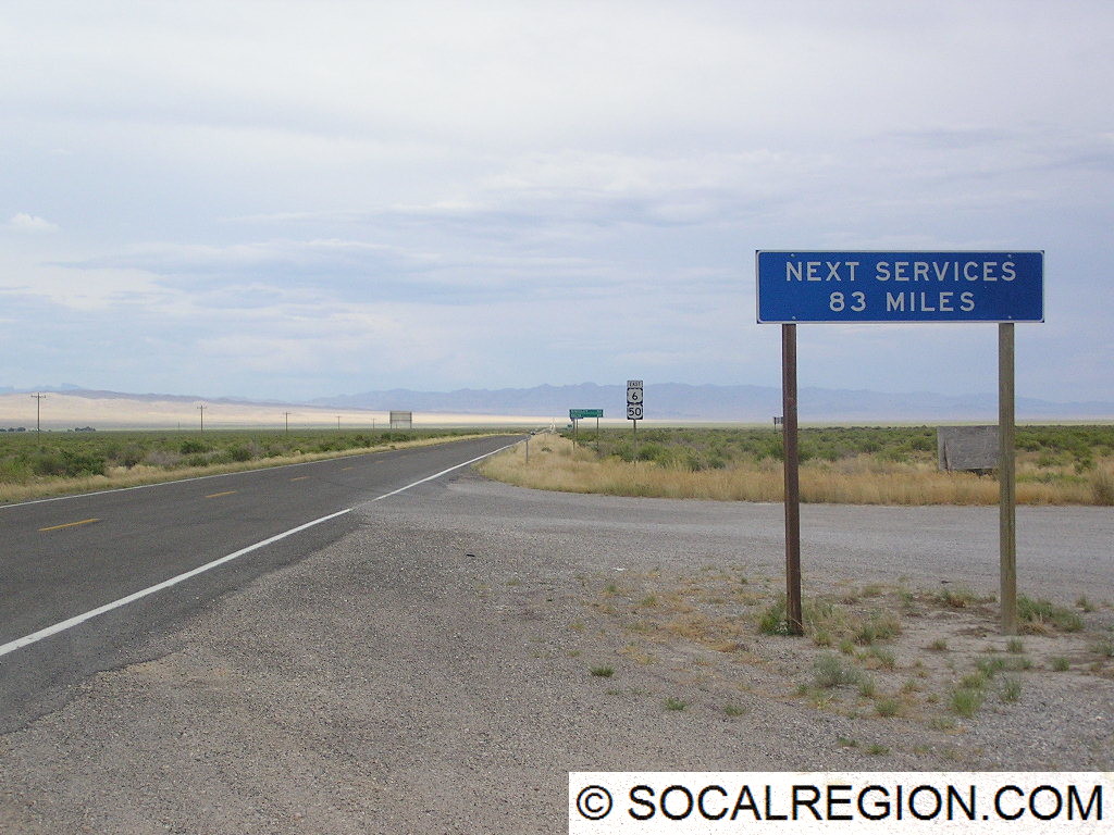
Blue signs are very specific in use. They act as guides to hospitals, telephones, and where services can be obtained. Roadside services can include gas stations, food, and lodging. These signs can be quite helpful for roadway users that are unfamiliar with the area and are not sure what sort of services can be obtained at a particular exit. Use of these signs varies by state as well. Some states show specific businesses, where others are more general, e.g. “Gas, Food, Lodging – Next Exit”.

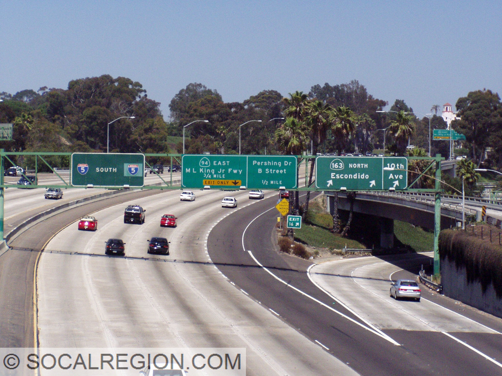
Green signs are also guide signs. These give directions, by use of an arrow, to locations such as cities and roadways. They also give mileage to locations along a route. On freeways they generally show distances to the next exit, where others show distance to the next three cities. They may also mark things such as bike routes, which are roadways where there is no marked lane specific for bicycles but may be easier for bicycling in general.

There are also brown signs which mark recreation and historic area, such as beaches and parks. Park lands, such as national monuments, are marked with brown signs as well as forest areas. Beaches, such as the various State Beaches along the coast are marked with these brown signs as well.

The last signs covered here are orange. These are for construction areas. These signs perform a wide variety of tasks but always mark a construction area. These are to be heeded in part to ensure the safety of construction workers. Detour signs also use this color scheme and mark an alternate route in case the main route is closed. Always use caution in areas marked with orange signs. In addition to construction workers, roadway quality may greatly vary as well. Well-paved roads may be turned to dirt for a time during the construction and speeds may be greatly reduced from normal.
As you can see, road signs come on many shapes and colors. Each help roadway users get to their destination in all sorts of ways. So, next time you’re out on the road, keep this in mind and it may help you on your journey to wherever you may be going.
Featured Image – 11/30/2017

Featured Image – 11/11/2017

Highway Tips – Roadway Striping
This is the first part of a new series on SoCalRegion where we will discuss various topics related to roadways, their design, signage, as well as other features to help assist all road users in traveling throughout California. Many of these features exist in other states, but some have a different take on things.
Roadway striping comes in a few different colors and designs. Each of these have a meaning. Even without using signs, you can use striping to help determine what is going on with a roadway. Using these clues can also help aid with navigation in unfamiliar areas.
The Basics

Let’s start with the basics. Two basic elements of striping are common throughout the United States – yellow means dividing opposing traffic and white means same direction of traffic. These colors remain nearly universal throughout all 50 states. Double striping, no matter the color, denotes a “no passing” or “no crossing” location. Passing, assuming the roadway is two lanes wide, can be done when the stripe on your side is broken. When the whole stripe is broken, both sides can pass.
Divided Roads

Multilane highways are divided in a variety of ways. When it comes to striping, there are three main types. The first is still the basic double-yellow striping. When a roadway needs a bit more of a divider, two sets of double yellow stripes are placed. These are considered “painted barriers” and are not to be crossed in any way. Some of these roadways have breaks in the striping, usually on one side only, to allow for turns onto side streets or driveways.
Common center turn lanes are another way to divide a roadway. These can exist even on two lane roadways but are more common on multilane roads. These center lanes are striped with a solid yellow line on the outside and a broken yellow line on the inside. These lanes allow both directions to make left turns.

Freeways
Freeways, while the striping is color coded the same way as regular roads, do have some different styles and meanings. Exit Only lanes, meaning lanes that will exit a freeway shortly, have something Caltrans calls – Elephant Tracks. When a lane is going to leave the freeway, the striping changes in thickness and frequency. These stripes are wider and a little more frequent than regular lane striping. It is one of the visual cues that is designed to help motorists determine if they are in the correct lane, regardless of signage.
At the exit itself, the shoulder striping in California has a unique modification. Designed to aid motorists in times of reduced visibility, the shoulder stripe has a break at the exit and flares out to mark the exit. In areas subject to heavy fog, there is an additional exit cue – reflectors. These are off to the side of the shoulder striping at intervals and are in rows of three, two, then one at the exit.


HOV lane striping is another variation found on California freeways. Until a few years ago, these lane were, in general, striped with a double set of double yellow lines, acting as a painted barrier. There were variations based on available space as well. Specific entry/exit points where marked with broken white striping. These stripes are now being changed to double white lines with broken striping at the entry/exit points.
As you can see, there are many ways to determine what is going on with a roadway without looking at signage. Striping can help guide road users in ways signage cannot. So, when you are in unfamiliar territory or in conditions where you can’t see the signs, use these clues to help direct you to where you are going. The stripes are there to help!